
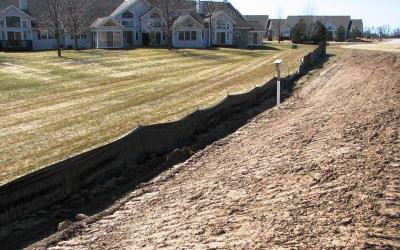
Erosion and uncontrolled stormwater runoff can have adverse impacts on both land and water. To reduce these impacts, either an Erosion Control Permit or a Shoreland Erosion Control Permit may be required depending on your project's location.
Erosion Control Permit - required by Dane County Ordinance Chapter 14 (PDF) for specific land disturbing activities that occur outside the Shoreland Zone.
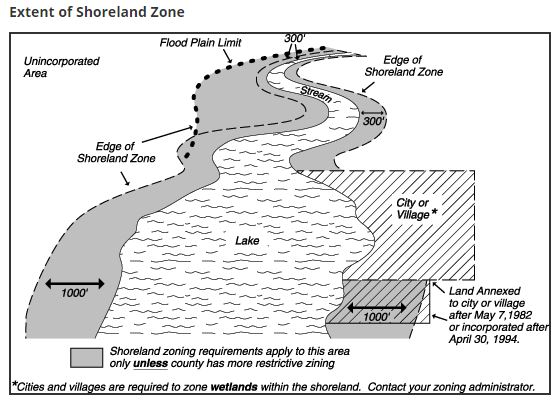
Shoreland Erosion Control Permit - required by Dane County Ordinance Chapter 11 (PDF) for specific land disturbing activities that occur within the Shoreland Zone (JPG). If your project is located within the Shoreland Zone, we recommend that you contact Dane County Zoning to determine if permits are required.
An Erosion Control Permit or a Shoreland Erosion Control Permit is required for any of the following:
The Shoreland Zone includes all lands within:
Permit application form(s):
Additional forms and information that may need to be submitted with your permit application(s):
Submitting an Application
Digital submittals for these permits can be uploaded to the WRE File Transfer Site. Alternatively, small projects could be emailed to WREDiv@danecounty.gov (< 10 MB file size)
Application Fee Payment
Electronic payment is preferred. To request an invoice, email WREDiv@danecounty.gov and include your project name and the email the invoice should go to. You may also pay by check mailed to our office. Checks should be made out to Dane County Treasurer and include the project name in the memo field.
What is a maintenance agreement?
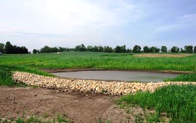
A maintenance agreement is a legal document recorded with the Dane County Register of Deeds that prescribes specific maintenance tasks for required permanent practices. All permanent stormwater management practices and vegetated buffers must be maintained in perpetuity. This document and associated maintenance responsibilities transfer with changes in ownership. The signed and notarized maintenance agreement and recording fee must be submitted prior to permit issuance.
How do I revise my permit?
Any changes to the approved plan or schedule need to be submitted for review prior to implementation. Revisions must be submitted in writing and will only be accepted prior to permit expiration. Please note, the permit cannot be revised or extended once it expires. At minimum, a revision consists of a written request and the supporting documentation (i.e., revised plans, revised schedule and soil loss analysis). Your consultant can help you prepare the necessary information.
What are as-built plans?
As-built plans are a record set of drawings submitted by a professional engineer following the completion of construction. As-built plans are required for all permanent stormwater management practices, including the vegetative buffer. As-built plans, along with an as-built certification, should be submitted within 10-days of completion of the project.
Where do I turn for assistance and background information?
The Dane County Erosion Control & Stormwater Management Manual provides information to help landowners, developers and consultants meet the requirements of Dane County's Erosion Control and Stormwater Management Ordinance. For more information about this topic, visit the Stormwater-related-Permits webpage.
How long does it take to get permit approval?
Applications are reviewed in the order they are received. Staff will inform you or your consultant of plan deficiencies or permit approval within 15 working days. Deficiencies can be corrected by revising the application materials or submitting additional information. In some cases, simplified permit applications can be reviewed and issued usually within 3 days. For simplified review, please contact wrediv@danecounty.gov or call (608) 224-3730 to be directed to the appropriate staff member.
How long is my permit good for?
Erosion Control Permits are issued for the timeframe specified in the approved plan, and expire on the stabilization date as described or included in the soil loss analysis. Erosion Control Permits can be issued for a maximum period of 3 years. Stormwater management permits are issued in perpetuity and do not expire. The permit expiration date is described in the approval memo and printed on the permit card.
How do I know if my project is located in the Shoreland Zone?
DCiMap online mapping application may be used to determine if your project is located in the shoreland zone. Simply enter the address or tax parcel number of your project in the search field in the upper right corner or navigate to the location of your project on the map. Once zoomed to the location of your project, click on the "Map Layers" button located in the upper-right hand corner of the page. Then, click on the water drop icons and scroll down and check the "Shoreland Zone" checkbox. Any hatched area is considered within the Shoreland Zone.
Design Resources
Additional Resources
For any questions regarding erosion control or stormwater management permits, please feel free to reach out to Dane County staff. To find the staff contact in your area, view the Staff Contact Map. If you can’t tell who your staff contact should be, please email Water Resource Engineering wrediv@danecounty.gov or call the office (608) 224-3730.
