Over the last few decades, the phosphorus concentrations of the Yahara chain of lakes (Mendota, Monona, Waubesa, Kegonsa) have led to an increase in the frequency and extent of algae blooms, creating green, slimy lakes and beaches. Sources of phosphorus including livestock manure and fertilizer attached to sediments, or dissolved in water, which are then transported to streams and lakes through rainfall runoff. For several decades the Dane County Land & Water Resources Department has assisted agricultural producers with conservation practice implementation to prevent soil erosion/barnyard runoff -- this is an essential step towards preventing additional phosphorus from entering the streams and lakes. However, the question remained as to why algae blooms were still occurring despite decades of conservation work.
Breakthrough research in 2014 by Dane County in collaboration with the Wisconsin Department of Natural Resources (WDNR), discovered that phosphorus concentrations in the stream sediments of Dorn Creek (northeast of Lake Mendota) are seven times greater than nearby crop fields. Much of the stream sediment is known as legacy sediment, deposits formed by erosion from farm fields accumulating over decades of farming. In the case of Dorn Creek, this sediment has existed since the late 1800s. For Lake Mendota, if the accrued legacy sediment remains at the bottom of the streams, it was calculated that it would take almost 100 years for the phosphorus to continue to leach out of the sediments and enter the lake.
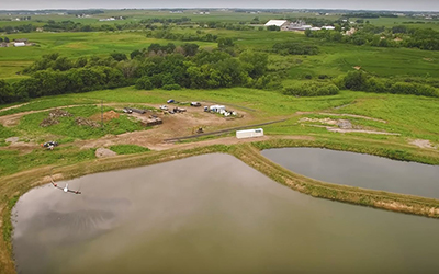
In order to reduce phosphorus concentrations and improve water quality decades sooner than 100 years, Dane County developed an innovative project to remove the phosphorus-laden sediment from the streambeds within the Yahara watershed. The segments were selected in consultation with WDNR based on which segments had a large amount of legacy sediment. A map showing the segments and the current progress at each location is in the Timeline section below. A project summary is available in a Story Map from the Rock River Coalition.
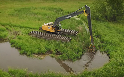
During this multi-year project, phosphorus-laden mucky sediments are removed with a hydraulic dredge and pumped into dewatering basins. The basins will eventually be restored to native prairie cover that will reduce runoff and increase infiltration.
The project will be completed in two phases - see Phase & Status Map (PDF).
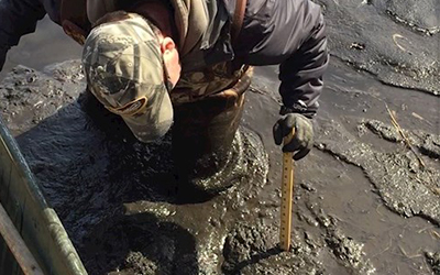
Phase 1 involves the assessment of the stream and sediments in the proposed locations (see map below). The assessment consists of an evaluation of habitat health and laboratory analyses of sediments. Habitat health provides information on existing conditions in order to ensure future sediment removal does not degrade the health of the aquatic system. Laboratory analysis is performed to determine if existing phosphorus amounts in the stream sediments will improve water quality by their removal. Also, the sediments are analyzed for contamination (e.g. heavy metals, PCBs) to determine the appropriate sediment removal techniques to maintain the health of the aquatic system.
Proposed Phase 1 Assessment Timeline:
Depending on the results of Phase 1, the site may be selected for Phase 2.
Phase 2 involves the creation of construction documents, submittal of permits, acquisition of construction easements to perform removal of stream sediments, and the removal of stream sediments awarded through a competitive bid process.
Phase 2 Sediment Removal Projects Completed or in Progress:
October 29, 2024 - Sediment removal and re-meandering of Door Creek north of the railroad tracks is complete. Restoration south of the railroad tracks is now underway.
October 1, 2024 - The Door Creek Wildlife Area will be closed from July 8th through December 31st, 2024.
July 3, 2024 - Midwest Amphibious Equipment will begin construction in the middle of July. As part of this work, they will be utilizing the Door Creek Wildlife Area. The green/orange areas identified in the Project Map (PDF) will be CLOSED from July 8th through November 1st, 2024 for construction.
April 22, 2024 - The contract for Door Creek Restoration has been awarded to Midwest Amphibious Equipment. The contractor plans to start in summer of 2024.
March 5, 2024 - Construction plans are complete for sediment removal and restoration of Door Creek. Work is anticipated to start in the summer/fall of 2024.
Dane County Land & Water Resources Department
(608) 224-3730
lwrd@danecounty.gov